Lover’s Retreat in Lake Charles: The Pithon Coulee Boardwalk
Geographic description
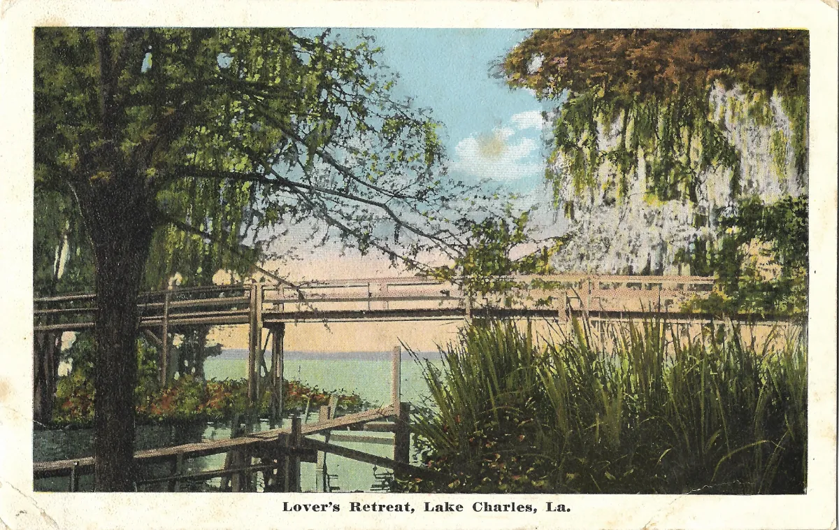
Lover’s Retreat Lake Charles is shown on this vintage postcard as a picturesque wooden walkway winding through the lush wetlands of southwestern Louisiana. The printed caption at the bottom, “Lover’s Retreat, Lake Charles, La.,” clearly identifies both the attraction and the city, with “La.” standing for Louisiana.
Lake Charles lies in southwestern Louisiana and is the seat of Calcasieu Parish. The city developed beside the lake from which it takes its name, within a landscape historically shaped by the Calcasieu River, bayous, coulees, and extensive low-lying wetlands.
Several sections of an elevated wooden walkway can be distinguished in the postcard. Upright posts support narrow decks fitted with simple horizontal railings. Rather than forming a single straight bridge, the structure appears to turn through the vegetation, suggesting a recreational path designed to lead visitors through the swamp.
Historical documentation closely matches what can be seen here. According to the Calcasieu Historical Preservation Society, Lovers’ Retreat was completed in 1888. It was a long, winding bridge or walkway over Pithon Coulee, beginning near Front and Clarence Streets and continuing south and west through a dense cypress swamp. At its western end, it joined the old shell road.
The postcard preserves much of the secluded atmosphere that presumably gave the place its name. Large trees arch over the boardwalk, while tall plants and undergrowth fill the foreground. Hanging vegetation resembling Spanish moss contributes strongly to the Southern wetland character of the scene. Pale green water can be glimpsed between the wooden structures and plants.
“Lover’s Retreat” should therefore not be understood primarily as the name of a building or resort. The historical evidence indicates that the attraction was the walkway itself and the natural setting through which it passed. Its romantic name suggests that it was regarded as a quiet place for strolling, away from the busier streets of the growing town.
The location changed dramatically during the early twentieth century. The surrounding area later became associated with Margaret Place and Shell Beach Drive. Today Shell Beach Drive follows the southern shore of Lake Charles and remains one of the city’s important historic and scenic corridors.
The postcard is therefore valuable not simply as an attractive Southern landscape, but as a record of an earlier geography that has largely vanished beneath later streets and residential development.
Historical description
The walkway represented here dated from 1888, a significant period in the development of Lake Charles. During the 1880s the city was undergoing rapid economic expansion driven especially by the lumber industry. Lake Charles benefited from its position on waterways suitable for moving timber, and the arrival of the railroad in 1880 further improved transportation. Louisiana’s historic preservation documentation describes the city as an important center of the state’s major lumber boom of the late nineteenth and early twentieth centuries.
Lover’s Retreat thus appeared at a time when Lake Charles was evolving from a relatively small settlement into a prosperous regional center. The boardwalk represents another side of that growth: as population and prosperity increased, spaces were also being created for recreation and leisurely walking.
The postcard itself is a colorized printed view, a style strongly associated with early twentieth-century postcard production. Greens, blues, and other tones were probably applied or enhanced during the printing process and should not be interpreted as an exact photographic record of the original colors. No publisher’s name or definite printing date can be identified from the visible front of this card.
Historical changes to the site, however, provide an important dating clue. During the redevelopment of the Margaret Place area in the early 1910s, low swampy ground around Pithon Coulee was drained and reclaimed. Historical accounts state that the old lovers’ lane and walking bridge were demolished as a new carriage road—today’s Shell Beach Drive—was constructed. The final Margaret Place subdivision plat was recorded in October 1912.
Because the postcard clearly depicts the old walkway, the original photograph was most likely taken before the redevelopment of the early 1910s. A photographic date of approximately 1900-1912 is therefore plausible. The postcard itself could have been printed or sold somewhat later, since publishers regularly continued to use older photographs after a landscape had changed.
The transformation was substantial. What had been a secluded wooden path through Pithon Coulee became part of an increasingly urbanized lakefront neighborhood. Shell Beach Drive subsequently gained wider significance when it formed part of the Old Spanish Trail, the transcontinental highway route conceived in 1915 to link the southeastern United States with California.
This postcard consequently captures a short-lived stage in the history of Lake Charles: a period when the growing lumber city still bordered cypress wetlands close enough to its center for residents to reach them on foot. Lover’s Retreat has disappeared, but the postcard preserves the appearance of that landscape before drainage, road construction, and residential development transformed the southern shore of the lake.