Pacific Avenue and the Gateway to the City circa 1907
Geographic description
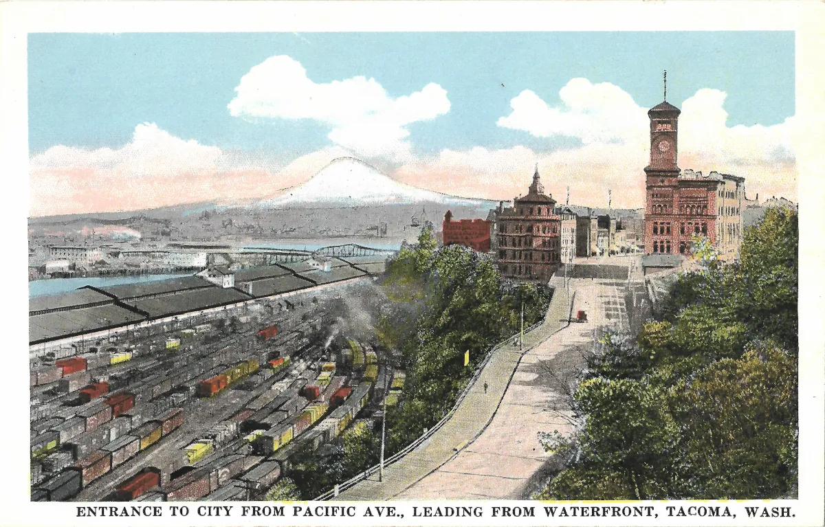
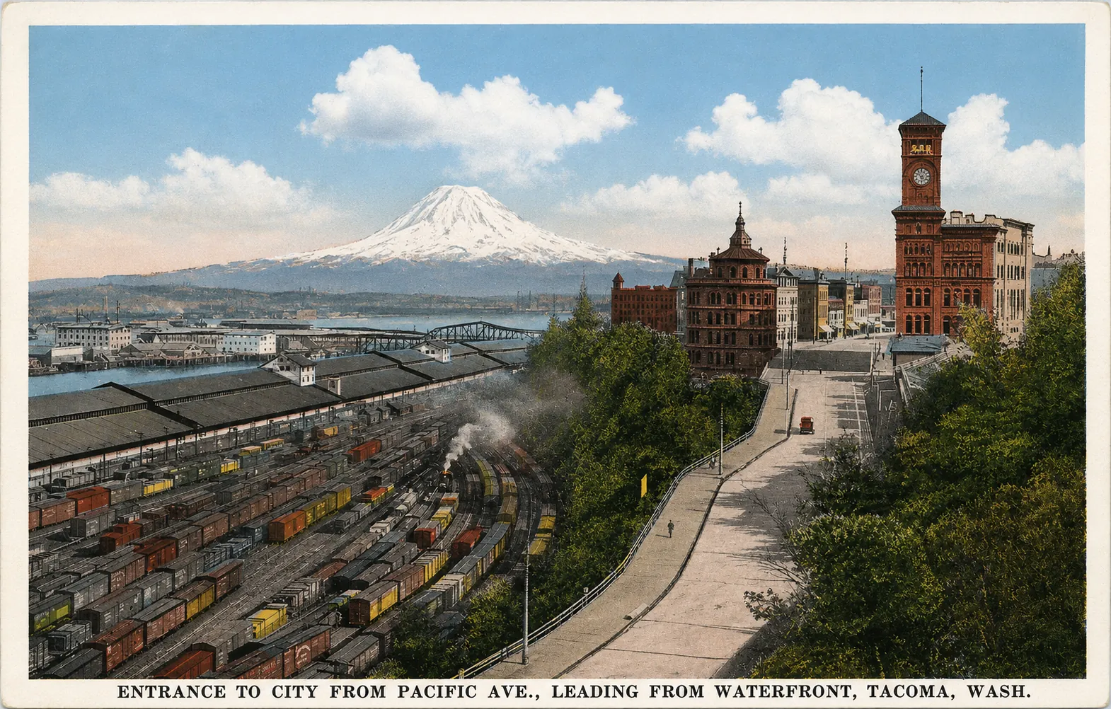
Pacific Avenue Tacoma is presented on this vintage postcard as the gateway between the waterfront, the railroad district and the heart of the city. The printed caption, “Entrance to City from Pacific Ave., Leading from Waterfront, Tacoma, Wash.,” clearly identifies both Tacoma and the approach represented in the picture. The photographer was positioned above the northern edge of downtown, looking toward the imposing civic and railroad buildings that marked the end of Pacific Avenue.
The most prominent landmark rises on the right. This is Tacoma’s original City Hall, now known as Old City Hall, with its tall brick clock tower and pyramidal roof. Completed in 1893, the building stands near South 7th Street between Pacific Avenue and Commerce Street. Its location on the bluff overlooking Commencement Bay was deliberately conspicuous, and historic-preservation documents describe it as the northern architectural anchor of Pacific Avenue.
Immediately to the left is another substantial building distinguished by a smaller tower. This is the former Northern Pacific Railway headquarters at 621 Pacific Avenue, completed in 1888. It stood directly across Pacific Avenue from City Hall. The juxtaposition was highly symbolic: municipal government occupied one side of the street while the railroad company that had played a central role in Tacoma’s rapid growth occupied the other.
The left half of the postcard is almost entirely devoted to railroad infrastructure. Numerous parallel tracks fill the foreground, crowded with freight cars in a variety of shapes and sizes. Tacoma Public Library records identify this complex as the Half Moon Yard, developed by the Northern Pacific on land created by filling part of Half Moon Bay. Pacific Avenue descended toward South Cliff Avenue, the roadway later incorporated into what is now Stadium Way. This historic arrangement explains the postcard’s description of the scene as an entrance from the waterfront: travelers approaching downtown encountered the railroad yards immediately below the city’s main civic and commercial district.
Beyond the city rises Mount Rainier, its snow-covered summit forming a dramatic background to the urban scene. The composition was ideal for early Tacoma promotion. Railroad tracks and freight cars represented commerce and industrial power; City Hall represented civic ambition; Mount Rainier supplied a spectacular natural backdrop associated with the Pacific Northwest.
The mountain’s apparent size should not, however, be interpreted as a precise photographic record. Historic discussions of this well-known Tacoma viewpoint note that postcard publishers sometimes retouched or enlarged Mount Rainier to strengthen the composition. The peak on this card may therefore have been emphasized during the production or coloring process.
The card itself is a colorized photographic reproduction rather than a straightforward color photograph. Pale blue skies, green foliage, reddish brickwork and brightly colored freight cars were added to make the scene more attractive. Although the colors should therefore be treated cautiously, the street layout, railroad tracks and major buildings provide an unusually informative record of the relationship between downtown Tacoma and its waterfront at the beginning of the twentieth century.
Historical description
The original scene can be dated with reasonable confidence to approximately 1907-1910, although the precise printing date of this particular colored postcard cannot be established from the front alone.
Old City Hall provides an important chronological clue. The building itself had been completed in 1893, but the clock and chimes that became one of its defining features were donated in the early twentieth century, with HistoryLink placing the clock installation in 1905. Since the clock face is clearly visible in the postcard, the underlying photograph is later than that period.
More decisive evidence comes from the Tacoma Public Library’s Northwest Room. Its historical collections contain a remarkably similar view catalogued as Gateway to Tacoma and dated circa 1907. The archival description identifies the same principal features seen here: City Hall and its clock tower on the right, the Northern Pacific headquarters across Pacific Avenue, the Half Moon railroad yard to the left, and Pacific Avenue descending toward South Cliff Avenue.
The library also preserves other postcard versions of this celebrated viewpoint. An Anderson collection example titled Gateway to the City, Tacoma, Washington is dated circa 1907, while another postcard showing northern downtown, the two landmark buildings, the railroad yards and Mount Rainier is catalogued circa 1910. These records strongly suggest that the photographic scene used for the present card belongs to the late 1900s or very early 1910s. The colored edition itself could, of course, have been issued somewhat later.
The picture captures Tacoma during the period when its identity was inseparable from the Northern Pacific Railway. The railroad had selected Tacoma as its western terminus in 1873, helping transform the settlement into a major commercial and industrial city. By the time this photograph was taken, railroad tracks and freight facilities dominated large portions of the waterfront below downtown. The company’s headquarters building directly opposite City Hall made that economic influence physically visible in the cityscape.
The postcard was therefore more than a simple street view. Its “Entrance to City” wording turned the approach into a carefully composed advertisement for Tacoma. A visitor arriving from the waterfront was presented with three powerful symbols at once: an enormous railroad complex demonstrating commercial activity, monumental architecture expressing civic confidence, and Mount Rainier representing the grandeur of the surrounding landscape.
Both Old City Hall and the former Northern Pacific headquarters survive, although their surroundings have changed dramatically. The railroad landscape that once dominated the foreground has been altered by successive phases of transportation and waterfront redevelopment. As a result, this postcard preserves one of the most characteristic views of early twentieth-century Tacoma: a city whose downtown, railroad system and waterfront were still physically and economically intertwined.