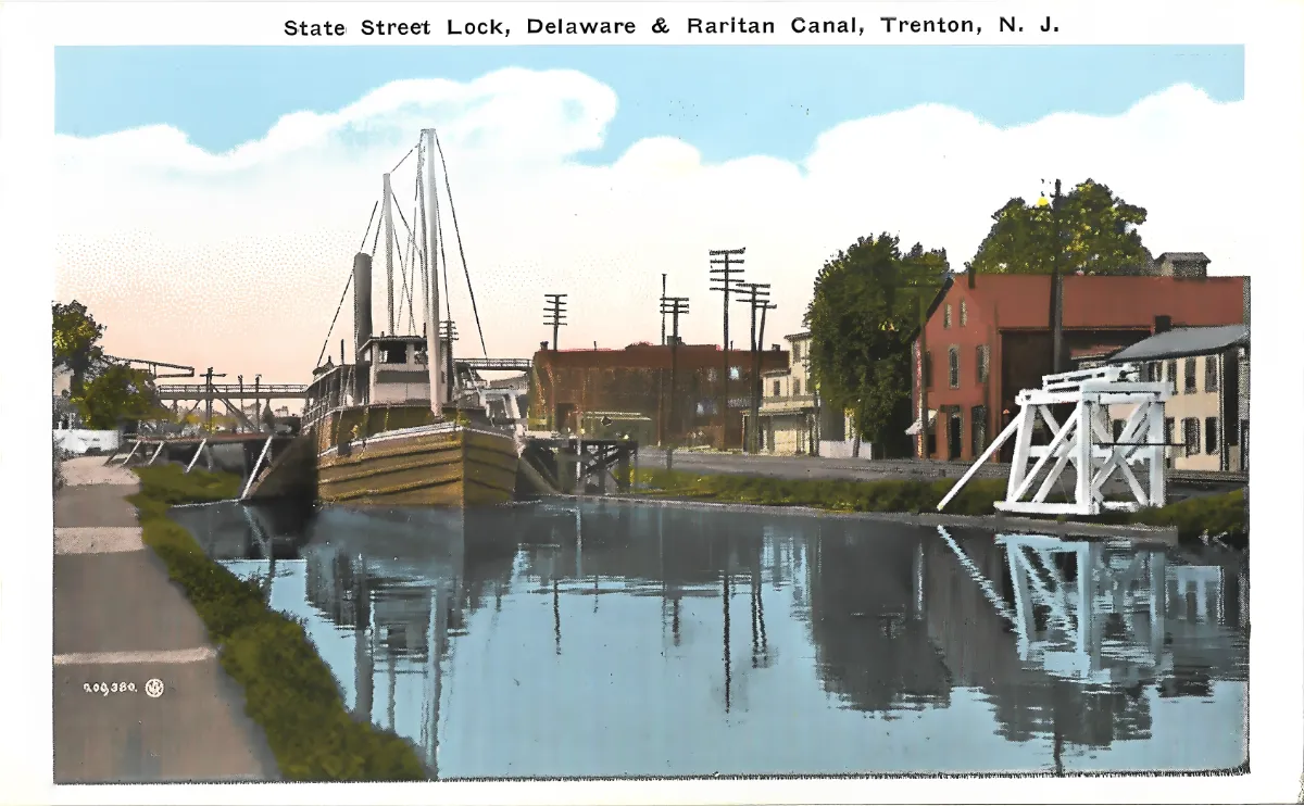
Antique Postcard Trenton New Jersey: State Street Lock
Geographic description:
This antique postcard Trenton New Jersey depicts the State Street Lock on the Delaware & Raritan Canal. The caption printed at the top of the card, “State Street Lock, Delaware & Raritan Canal, Trenton, N. J.”, is a certain data point since it is directly inscribed on the card itself rather than inferred.
The scene shows a canal reach lined by a towpath on the left bank and a cluster of industrial and residential buildings on the right bank. A large wooden canal boat, fitted with two removable masts and a raised cabin at the stern, is moored near the lock. This type of vessel, lacking any visible steam propulsion and built for hauling heavy freight such as coal or building materials, matches the towed or mule-drawn barges typical of American canal traffic in the late nineteenth and early twentieth centuries.
On the right bank stands a white-painted wooden structure with crossed timber framing and a pulley system: this most likely corresponds to the lock’s operating mechanism or to a lift bridge allowing pedestrians or vehicles to cross the canal when no boat is passing through. Numerous telegraph or electric poles lining the bank indicate that the area already had reasonably advanced electrical and telegraph/telephone infrastructure.
The buildings visible on the right bank include a multi-story red brick structure, likely commercial or light-industrial in use, alongside more modest wood or brick dwellings with gabled roofs. This built environment reflects the industrial urban fabric typical of Trenton’s riverside districts at the turn of the twentieth century, a period when the city was a recognized manufacturing center (pottery, wire rope, metalworking).
Historical description:
The printing style of this antique postcard Trenton New Jersey — a white border framing the image, colors applied through a lithographic colorization process, and a caption printed in ornamental capital letters — matches the characteristics of the so-called “White Border” era of American postcard production, generally dated between 1915 and 1930. This dating remains a hypothesis based on stylistic indicators rather than direct postal evidence, since no postmark or stamp appears on the recto provided.
In the lower left corner of the card is a partially legible edition number (“7.09.380” or a close variant) accompanied by a small circular emblem, likely the mark of a commercial postcard publisher active in New Jersey or the broader northeastern United States. The publisher’s identity remains undetermined based on the visible elements and would require verification against specialized American postcard catalogs.
The presence of a canal boat still in active use suggests that this stretch of the canal was still functioning commercially at the time the photograph was taken. It is historically established that the Delaware & Raritan Canal, completed in the 1830s, served for several decades as a route for transporting anthracite coal from Pennsylvania to East Coast ports, before railroad competition and the eventual end of commercial operation in the early 1930s brought its economic role to a close. The card therefore likely depicts, with moderate confidence, a state of affairs prior to that closure, probably sometime in the 1910s or 1920s.
The social context suggested by the image is that of a mid-sized industrial city, where river infrastructure coexisted with modern communication networks (telegraph/electric poles) and a dense working-class or artisanal housing stock. Since no handwritten message, postmark, or stamp is visible on the side provided, no precise postal dating can be offered: the estimate above rests solely on stylistic and technical analysis of the printing.
It should be noted that this card, depicting an American site (Trenton, New Jersey), falls under the site’s secondary category for postcards outside France, distinct from the main collection focused on French regions.